Introduction to R, spatial data and data management
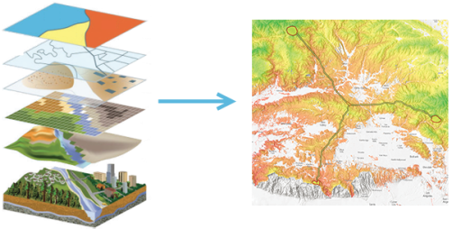 Example of stacking geospatial layers to model safe corridors between isolated cougar populations. Source: https://doc.arcgis.com/en/arcgis-online/reference/geo-info.htm
Instructors:
Allan Roberts (Bamfield Marine Sciences Centre)
Dr. Gabriel Reygondeau (UBC IOF - Nereus program)
Dates & Location:
---------- 3 workshop days ----------
830am - 430pm, Tuesday October 11, 2016
Location: Liu Institute for Global Issues, Multipurpose Room
830am - 430pm, Wednesday October 12, 2016
Location: Liu Institute for Global Issues, Multipurpose Room
830am - 430pm, Thursday October 13, 2016
Location: Liu Institute for Global Issues, Multipurpose Room
Description:
The introductory module will provide participants with the basics required for subsequent modules. It is designed for students with little to no programming knowledge in R, GIS, or spatial data systems. Students will learn the fundamentals in R and its spatial data applications. Students will learn to use and map spatial data according to various landscape features (e.g., temperature, altitude), with various projections and display lon-lat points of interest (i.e., field sites). By the end of this module, students will also be able to assess spatial data types and quality.
Day 1: Introduction to R. The first day of the introductory module will be led by Allan Roberts and it will introduce participants to R software. It will cover the basics of programming R (objects, classes, matrices, dataframes, functions, packages, support, help sources, and writing/reading data). Basic plotting will be covered (parameters, settings, exporting plots), which will provide the fundamentals to visualizing spatial data.
Day 2: Introduction to spatial data, Part 1. This session will be split into a morning lecture and an afternoon practical session, taught by Dr. Reygondeau and Allan Roberts respectively. Participants can expect to learn everything from creating spatial data, to manipulating spatial data in R (e.g., projecting, clipping, resampling data). Topics to be covered will include: spatial data file types, projections, datums, plotting spatial data in relation to landscape features (e.g., sampling sites!), and assessing spatial data quality and dealing with issues of spatial scale (resolution).
Day 3: Introduction to spatial data, Part 2. The morning session of Day 3 will be a lecture on biogeography theory by Dr. Reygondeau, which will provide a fundamental understanding of spatial data in ecology and evolution and a valuable precursor to the subsequent modules. PENDING: The afternoon session will be a practical 2-hour workshop on finding spatial data.